• Skip to primary navigation
  • Skip to main content

Trail Option

A personal geography of landscape and place, art and geo-science.

  • Home
  • TrailOption Blog
  • About
  • Contact TrailOption
  • Subscribe!
  • Lost Journals
  • Show Search
Hide Search

Birds

Desert nights in Big Bend

D. Craig Young · July 31, 2025 · 1 Comment

Evening window. Chisos Basin, Big Bend National Park, TX, USA

It is the heat that gets your attention – and pay attention because one needs to travel wisely in the late spring in Big Bend National Park, but it is the promise of evening birds and late-night dark skies that holds it. I had dropped into Lajitas, Texas, to attend a photo workshop focused on astrophotography in and around the desert, borderland park. Night photography avoids the intense heat of the day, of course, but we also explored various locations to experience the moods of this variegated landscape.

Border wall. An outcrop of cactus overlooking the valley of the Rio Grande, Big Bend Mountains State Park, TX, USA
Diagnols. Lava intrusions along the Rio Grande, Big Bend Mountains State Park, TX, USA

The Big Bend topography is refreshingly disorienting to me. Unlike the regular, linear pattern of the Basin and Range, the mountains of Big Bend seem circular; we travel around and into them, not over and through. Alluvial fans and consolidated pediments extend from the rugged uplands, these are familiar.  The Rio Grande gasps for refreshment, barely any flow this time of year – the canyon marking the national boundary more than the river. The Chihuahuan Desert, its incessant volcanic rocks colonized with a wild diversity of arid-adapted plants and animals, is somehow sharper and coarser than our western deserts. Although the landscape is wide open, I feel like I cannot see as far. Between convoluted ridges, gunsight canyons reveal a surprise of distant ranges and mesas, verifying that the desert knows no borders.

Fade to light. Chisos Basin, Big Bend National Park, TX, USA

While I am not attracted to group excursions typically, I have great friends at Muench Workshops, and their participants are like-minded and lovely to spend time with. I always learn new bits of technique, and with astrophotography, there can be unique skills to apply in the field and in image processing. I forget most of them almost immediately, but that is not for their lack of unselfish sharing and engagement. It takes practice, and more practice, but it remains so much fun.

Castellan night. Astrophotography at Cerro Castellan in Big Bend National Park, TX, USA

While I gave full attention to our daily astro tutorials – we would hide away in a cool conference room during the hottest part of the day, I engaged my wanderlust during late afternoon excursions in search of birds and sunset light. I was then ready to settle in with the group to practice dark-sky compositions from blue hour to well after midnight.

Sendero rio. Big Bend Mountains State Park, TX, USA
Simple dusk. Volcanic badlands below Cerro Castellan, Big Bend National Park, TX, USA

Our little group moved between the mountains and canyons, dropping to the river occasionally; anything to feel the evening releasing the heat of the day. Although Wayne and Matt had locations planned, we often detoured when the light caught our attention. They picked some amazing scenes, but our focus was technique so we could have been almost anywhere in the jumble of desert spires and ridges. We practiced variations on focus-stacking, time-blending, and multiple exposures to battle the digital noise of long exposures, high-ISO settings, and heat-affected sensors. We also practiced various low-level lighting techniques to bring warmth and detail to our scenes. The field craft is a bit fiddlier than I am drawn to typically, and the files take quite a bit of patience (and computing power) to process, but the results are, or can be, amazing.

Adobe y cielo. Big Bend Mountains State Park, TX, USA

I mastered nothing on this trip, but I was reminded that improvement continues with practice. I may use few of the skills and tricks that well-practiced astrophotographers bring to their scenes, but there are landscapes and landforms in the Great Basin that I want to capture under a night sky, so I will continue to practice (special thanks to Wayne Suggs and Matt Payne). There is nothing like being under a dark sky in a desert or mountain landscape. It heals concessions we make living in cities of artificial light and constant motion, and it wakes up senses we hide from ourselves most of the time. The photos are then reminders that we should go back to the dark, occasionally, to heal and wake up.

Plus, there are birds to enjoy in the blue hour as we wait for the stars to shine.

Coordinated color. Blue Grosbeak, Los Chisos Basin, Big Bend National Park, TX, USA
Vermillion Flycatcher. Big Bend National Park, TX, USA
Mexican Jay. Big Bend National Park, TX, USA
Greater Roadrunner. Big Bend National Park, TX, USA
Morning drift. Common Nighthawk, Big Bend National Park, TX, USA

Keep going.

In memory of my nephew, Robby Young, who we lost so suddenly and too soon, while I was in Big Bend (June 2024). I did not see him enough, and I cannot see him again. But I will always have a reminder of him when under a dark sky, where the stars feel close enough to touch, even as they continue their journeys, far, far away.

Quick camp on Miller Canyon Fan, western Utah

D. Craig Young · July 26, 2025 · Leave a Comment

Panoramic photo showing beauty of Sevier Basin, Utah
Gunnison distance. The broad expanse of Sevier Valley after a storm, Great Basin Desert, UT, USA

Waypoint: Miller Canyon Alluvial Fan, Sevier Valley, Utah

After a warm day of landform reconnaissance in the Great Basin of western Utah, I camped in a small back-berm playette on the broad alluvial fan of Miller Canyon extending from the House Range in western Utah. The playette – a miniature dry lake – formed behind a relict gravel berm of pluvial Lake Gunnison, building over thousands of years as loessic alluvium scoured from the hillslopes settles behind the abandoned berm. This is the modern setting on the expansive alluvial fan – a small dry lake nestled behind a beach long after the once vast pluvial lake faded and dried, its lakebed shrinking to the playa of the Sevier Basin. The berm provides a stage for photographing storms that try and fail, evaporating into the evening skies of the Great Basin. The variegated color of a juvenile Brown-headed Cowbird greeted me as I rolled out of my sleeping bag the following morning. Altogether, a somewhat typical experience during geoarchaeological fieldwork in the Great Basin Desert. Keep going.

Glow squalls. Watching the storms pass from a small playa below Miller Canyon, Great Basin Desert, UT, USA
Skies over House Range. Great Basin Desert, UT, USA
Thirsty bird. A young Brown-headed Cowbird searches camp for water, Great Basin Desert, UT, USA

[2024.05.15 — Bonneville Basin Recce with Brian Codding (Univ of Utah) and Daniel Contreras (Univ of Florida); aka, The Strandline Society].

“These images and words are a reflection, simply and wholly, of my respect for our public lands and the public science and occasional art I am, and we are, able to do there. Our ability to create and think are not trivial, and wild space and healthy ecosystems nourish such things. It is here that we will find our better selves, even as the misdeeds of a few threaten much that, until recently, provides for our common good. Keep going.“

Please respect the natural and cultural resources of our public lands.

#naturefirst #keepgoing

Nevada High Points #128 – Slate Ridge

D. Craig Young · December 31, 2024 · 8 Comments

Desert walk. The Mount Duffee bajada, coalesced alluvial fans of Slate Ridge, Mojave Desert, NV, USA (Map point #1)

Mount Dunfee

7064 ft (2141 m) – 1647 ft gain

2024.11.13


I am on the road again. Having arrived home from northwestern Nevada only recently, I need to be in southern Nevada for some time in our Desert Branch office and a quick bit of fieldwork near Rogers Dry Lake in southeastern California. It is one end of the state to the other, and from the Great Basin Desert to the Mojave.  I enjoy the quick transitions, one ecology to another, Basin and Range to the Walker Lane tectonic silliness, and the travel day provides the opportunity to explore another high point without much of a detour. South of Goldfield, Nevada, I turn west at Lida Junction before heading into alluvial expanses below Slate Ridge.

This small, circular range is a tilted block of limestone and volcanic rocks, with actually very little slate, but for dispersed outcrops east of Mount Dunfee, the range high point. Not only is there little slate, Slate Ridge is not much of a ridge either. It has some fantastically dramatic outcrops and steep slopes, but it is really a complex jumble of hills and volcanic plateaus; however, from the historically minded town of Gold Point at its base, the western prominence of Slate Ridge is nicely imposing and ridge-like, if not slatey.

Welcome party. Joshua Trees on the fans of Dunfee Peak, Slate Ridge, Mojave Desert, NV, USA (Map point #2)
Map of the alluvial bajada along the western front of Slate Ridge and Mount Dunfee. Note the surface texture and general shapes of the oldest (Qa1) to the youngest (Qa4) individual alluvial fans and pediments.

Vague roads head toward various prospects visible on the slopes at the mountain front. I follow a maintained route before parking where a two-track intersects and provides a good start point. I have some wide bajada to cross before the steeper slopes begin. A bajada is a typically broad, mountain-front apron of coalesced alluvial fans, each emanating from its own canyon. Individual fans have their own source areas, with rock types in the fans matching the geology of their canyon sources generally. Because this region remains tectonically active, each tectonic jump or sheer along the mountain-front tilts the fan upward or moves the source canyon aside. The actions are quick, and the fans continue to build in the long quiet intervals in between – weathering and flashy floods cutting into and delivering sediment to the fans of the basin below. The lifted fans are isolated as gullies incise, and we can look at the degree of surface weathering and incision to place each fan and each tectonic change in time. The fan patterns are evident in aerial imagery, but there is nothing better than walking across the landforms themselves. It is why I visit these places.

Contacts. Beds and folds on the southwest fact of Dunfee Peak, Slate Ridge, Mojave Desert, NV, USA (Map point #3)

And, yes, there is the high point to reach. There are mining prospects where the fans intersect the mountain front, and the slope steepens into a nice climb. I soon notice circling raptors as I gain the ridge leading to the Mount Dunfee summit. There are several large birds, but one stands out, and its prominence does not go unnoticed by other birds who are doing their best to alter the larger bird’s slow, soaring path. The Golden Eagle merely shrugs at the swoops and dives of the Red-tailed Hawks; it looks as if the eagle is just passing through, veering close to the roosts of the juvenile hawks unknowingly. The Golden continues its straight-line glide path unperturbed.

Spotter. Red-tailed Hawk watches my approach to Dunfee Peak, Slate Ridge, Mojave Desert, NV, USA

I am soon on the summit of Mount Dunfee, a rounded dome among a scattering of cliffs. But something seems wrong. This is the named location of Mount Dunfee; I can, however, see a clearly higher summit to the northwest. It is, maybe, a half mile away, and one of the hawks is perched there. It is a sign!

Sentinel. A Red-tailed Hawk sits on the Mount Dunfee summit outcrop, I have to wait, Dunfee Peak, Slate Ridge, Mojave Desert, NV, USA (Map point #4)

It is not unusual to have a few summits of similar elevation in a summit cluster, especially among the smaller groups of hills or even along the high ridge of a prominent range. I am often, therefore, second-guessing the labels shown in map apps and other sources. I tend to trust the USGS topographic maps, but even these sometimes mark a named point that is not the high point. This seems to be the case along Slate Ridge. The hawk sensed my brief confusion and helped me out; it seems so, anyway.

The actual high point is more dramatic and precipitous than its rounded, illegitimate twin behind me. The hawk remained perched on the pinnacle until I got close. I hated to disturb it, but it had been watching every movement of my approach, so it was not startled or stressed. Its job done, I found the summit register, and I could enjoy the expansive views toward the Sierra and deep across the ranges of Nevada. There is just enough wind to lift the several hawks – the eagle is far away now – in various swirls and glides among the cliffs and canyons surrounding me. There are at least six raptors close by; maybe more, but I cannot turn quick enough to decide if I have counted that one or that other one, once or twice. A pleasure to watch for a while, nonetheless.

Hill space. Weather ridge top on the way to Dunfee Peak, Slate Ridge, Mojave Desert, NV, USA (Map point #5)

It is another wonderful day in a small, generally unknown group of hills in the midst of Nevada. I could digest the setting of the mountain-front alluvial bajada before reaching heights enjoyed by a kettle of raptors (yes, I looked up ‘kettle’).  The descent is easy, and I can soon continue my drive toward Las Vegas Valley and points beyond.

Serrated. Lichened outcrops on the ridge of Dunfee Peak, Slate Ridge, Mojave Desert, NV, USA. (Map point #6)

This might be my final high point of 2024. I made it to 13 this year, so far, and I am very happy and fortunate to be able to wrap so many summit excursions into my general travels. I hope for one a month, if only to keep the discipline of getting out, being curious, and learning.

Here’s to more high points in 2025. Thanks for coming along with me here at TrailOption; I look forward to hearing from you and, maybe, seeing you out there.

Keep going.

Please respect the natural and cultural resources of our public lands.

#naturefirst #keepgoing

Avocets of Kobeh Valley, NV

D. Craig Young · January 30, 2024 · Leave a Comment

Quarry home. American Avocet foraging in a gravel quarry, Kobeh Valley, Great Basin Desert, NV, USA

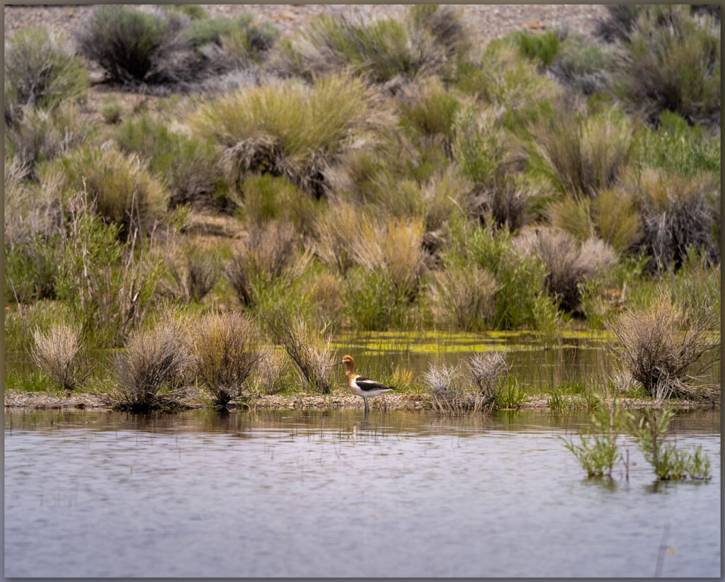
My work as a geoarchaeologist keeps me in the backcountry of Nevada for long parts of the year. I am fortunate to see the sagebrush ocean, while sometimes venturing into the sharper seas of the Mojave, across the seasons. In the late spring of 2023 I was mapping inset landforms in Kobeh Valley, Nevada, along Highway 50 when I cut across the valley on a dusty road to check out a gravel quarry. These quarries, developed for road construction and repair, stand out as small hills amongst the level sage. I seek them out, detouring haphazardly from my path, to look at the stratigraphic window into the landforms that the provide. I have been known to call gravel quarries ‘pluvial lake indicators’ as highway departments can often find ancient gravel bars where no other evidence exists.

Avocet Image Collection

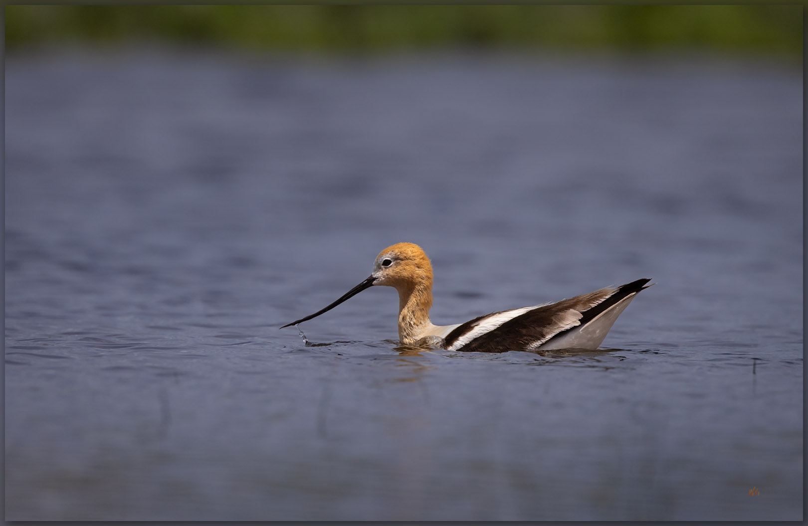
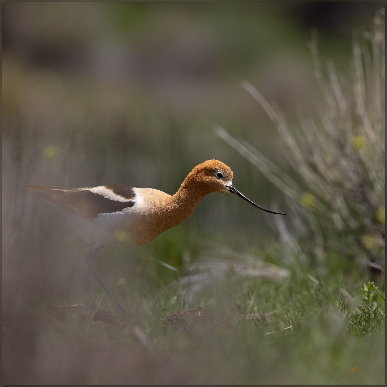
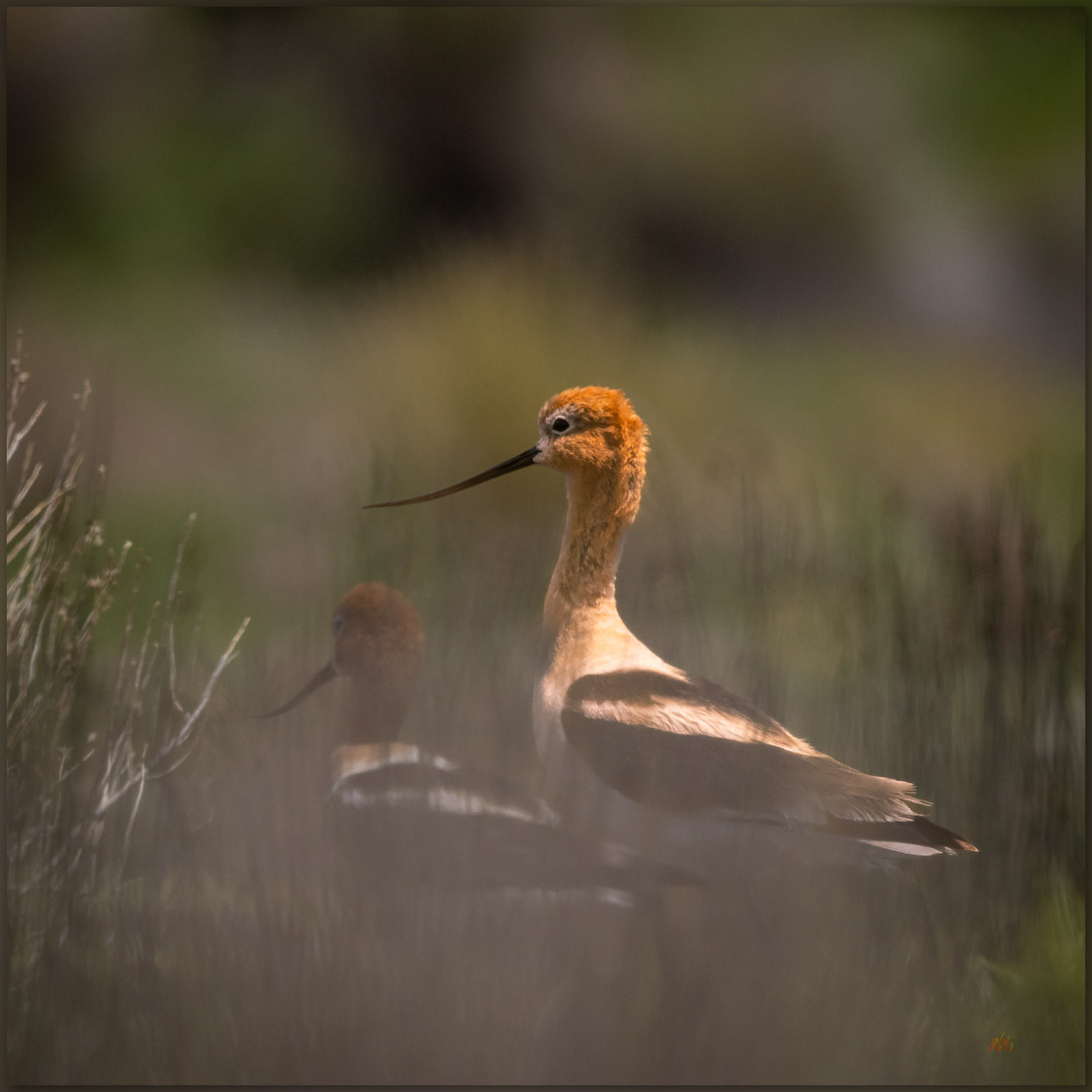
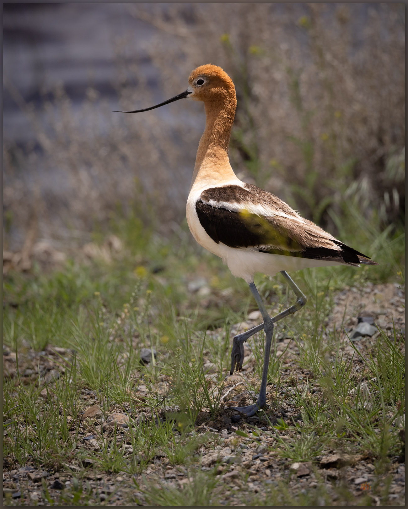
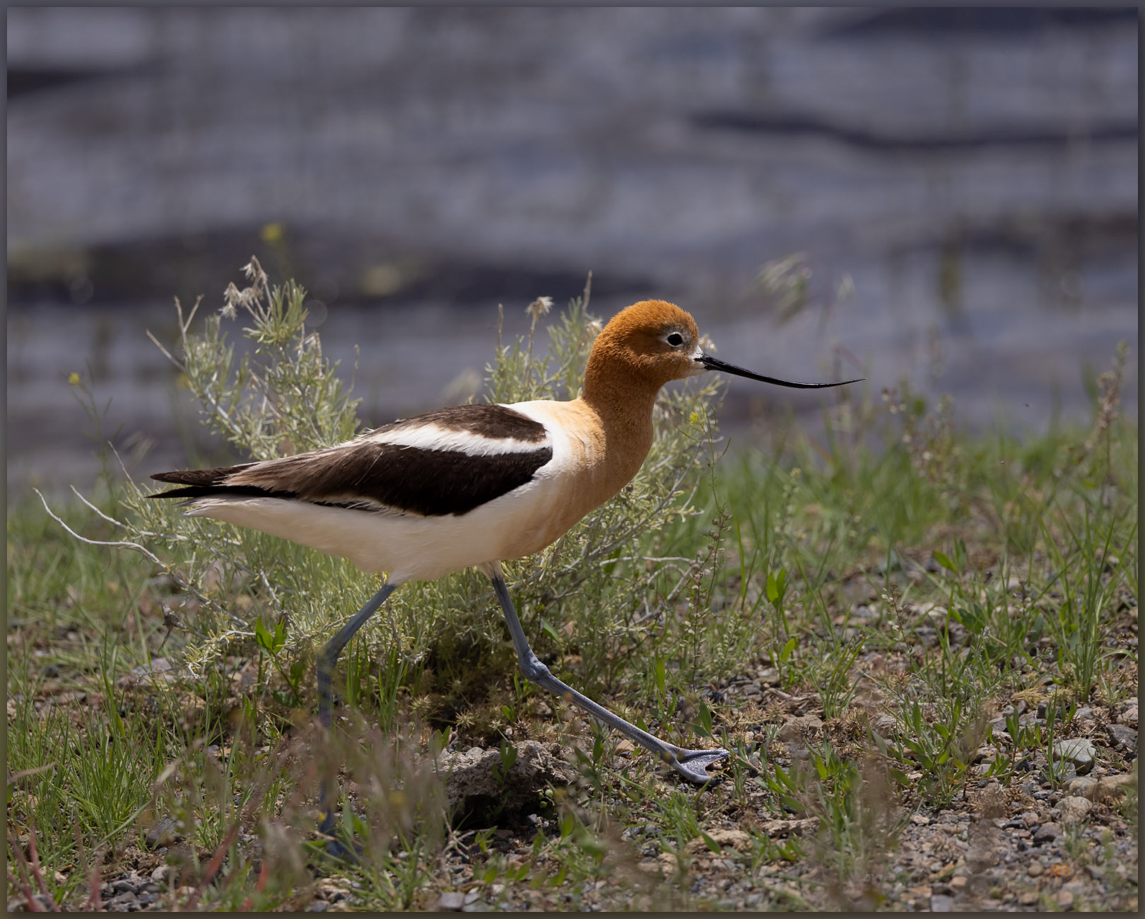
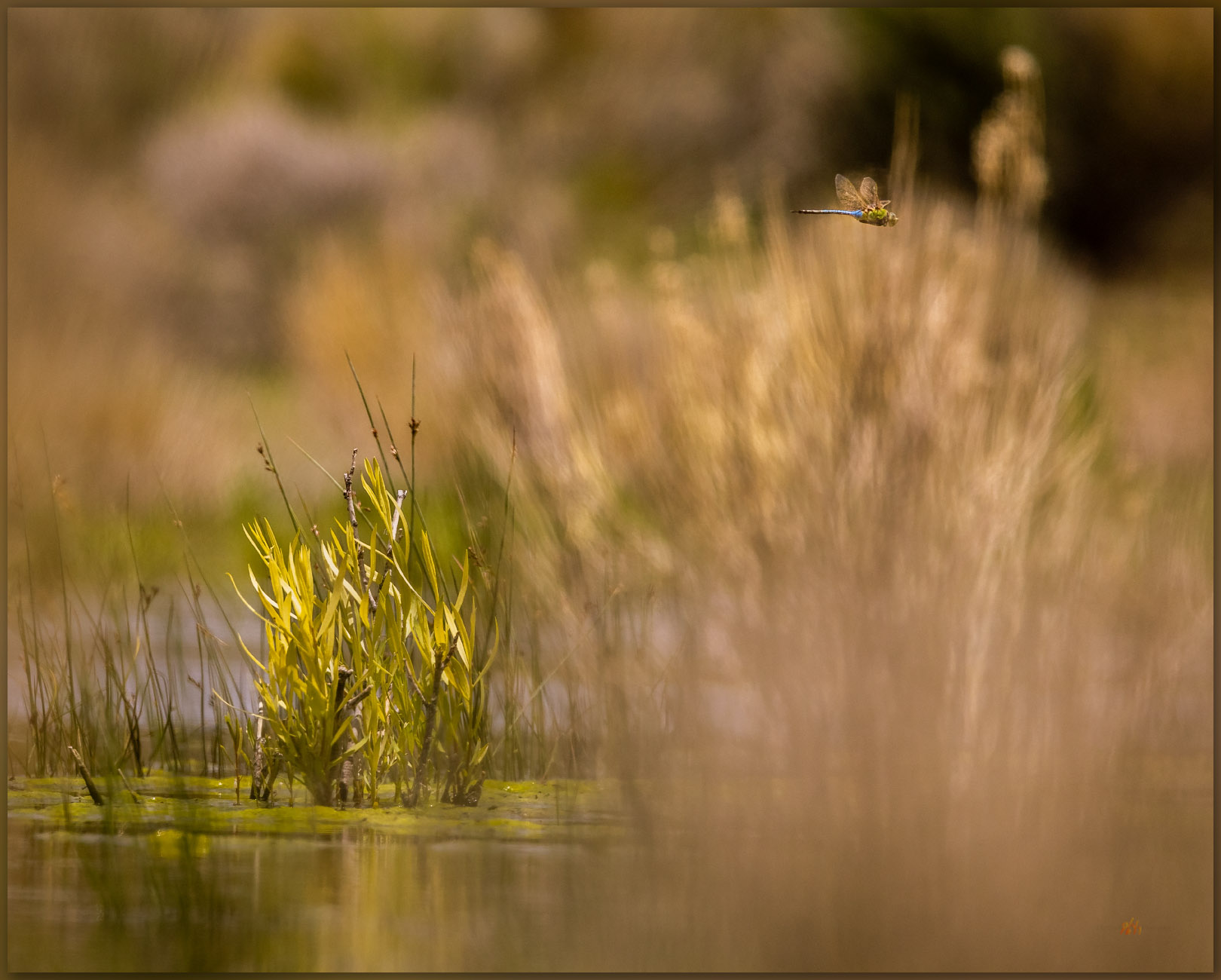
On this day in early June, with a thunderstorm in the distance, I drop behind a horded pile of gravel at the edge of broad pit to find that its rim encompasses a postage-stamp oasis of wetlands and ponds; it is maybe the size of a couple tennis courts. Two pair of American Avocets wander the shore, flushing in a quick circle as I approach and stop dead in my tracks. I abandon my truck, quietly grabbing my camera and a long telephoto. I will lay at the pond margin a while until they settle in to my quiet presence. It is worth the wait.

Floating by. An American Avocet in a quarry pond, Kobeh Valley, Great Basin Desert, Nevada, USA
Forage ahead. An American Avocet moves between ponds, Kobeh Valley, Great Basin Desert, Nevada, USA
Working together. American Avocets in Kobeh Valley, Great Basin Desert, Nevada, USA
Avocet pose. American Avocet on the shore of a gravel quarry, Kobeh Valley, Great Basin Desert, Nevada, USA
Avocet stride. American Avocet, Kobeh Valley, Great Basin Desert, Nevada, USA

I would love to hear what you think of these. And hear of any places you might have seen these lovely birds in the drylands of western North America, or wherever your journeys, near and far, have taken you.

Dragon fly gone. Kobeh Valley, Great Basin Desert, Nevada, USA

Avocet Image Collection

Keep going.

Click to subscribe!

Please respect the natural and cultural resources of our public lands.

#naturefirst #keepgoing

Wildlife Photography: Getting Lost with the Red-headed Woodpecker

D. Craig Young · April 18, 2021 · 2 Comments

Red-headed Woodpecker | Melanerpes erythrocephalus; foraging for pinyon nuts. Virginia Range, Great Basin Desert, Nevada.

Ok, this is not a bird photography website. It just happens that this was an interesting week.

Six-Mile Woodpecker Collection

After our brief birding excursion along the East Walker River, Desna heard that a Red-headed Woodpecker had taken up brief residence in Six Mile Canyon in the Virginia Range, just below Virginia City, Nevada. This is interesting because the poor bird seems to be a bit lost. Their common range is east of the Rocky Mountains, with only occasional appearances in the West.

Des made a successful sighting in Six Mile Canyon, along with a few other Reno-Carson-area birders out to add this to their lists and to enjoy the attractive, colorful bird. She said I should get up there and get him for my new avifauna image list. That was recommendation enough, so I went up early on a weekday morning – strange to drive into Six Mile and up to the outskirts of Virginia City, a place we lived for almost ten years. Happy to see Shaun and Debbie right off; Desna had also let them know that they had a visitor in their town.

We waited along the road, hoping he would come out for some morning foraging. This was the reported pattern. Sure enough, after about 45 minutes of waiting, I saw the white wing-flash, moving from the pinyon forest on the hillside to the cottonwoods of the riparian corridor. Unfortunately, the daily flow in the Six Mile drainage is augmented by the town’s effluent plant. But the birds do not seem to care.

Red-headed Woodpecker | Melanerpes erythrocephalus. Virginia Range, Great Basin Desert, Nevada.
Red-headed Woodpecker | Melanerpes erythrocephalus; eyes closed, perched. Virginia Range, Great Basin Desert, Nevada.

The Red-Headed Woodpecker worked his way around the cottonwoods. It was a challenge to capture images of the bird as he was adept at hiding in branches and trunks as he forages. We lose sight of him for long periods and then he reappears in a flush of red and white. Although my images are pretty good (I still need to develop the skill of getting a few more sharp images) it is very fun to share some time with a relatively uncommon bird. I have only been ‘birding’ for a few days, and I now have a rare one on my short list. Very fun, with more practice to come.

Red-headed Woodpecker | Melanerpes erythrocephalus; the bird of hearts. Virginia Range, Great Basin Desert, Nevada.

Six-Mile Woodpecker Collection

Bird Image List: Red-headed Woodpecker

Keep going.

Please respect the natural and cultural resources of our public lands.

#naturefirst #keepgoing

  • Page 1
  • Page 2
  • Go to Next Page »

Trail Option

Copyright © 2025 · Monochrome Pro on Genesis Framework · WordPress · Log in

  • Contact TrailOption
  • Substack
  • Waypoints Bibliography
  • Young Archives